 Complex and heterogenous volumes of data, including satellite and aerial imagery, can be used to improve the efficiency of an agricultural business. TERRASIGNA has developed AGRI-BIS, an online service that can address some of the most common problems that the farmers are facing: data integration, different databases for each activity sector, crops information for large areas.
AGRI-BIS offers:
- The localization of the parcels, crops and infrastructure together with their relevant attributes or characteristics;
- Centralized information about the leasing contracts, lands, documents;
- Automatic reporting in accordance to the user’s needs;
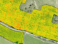
- Precision agriculture mapping.
AGRI-BIS is presented within the international trade fair of equipment and products in agriculture, horticulture, viticulture and animal husbandry - INDAGRA, that will take place in Bucharest, at ROMEXPO center, between 28 October - 1 November 2015.
TERRASIGNA professionals will be in Pavilion C6, stand 18!