Satellite data for coastal management to cope with climate change: Review of the European programme "ESA Coastal Erosion"
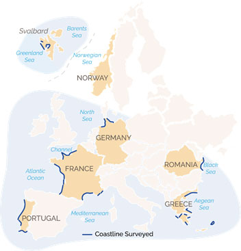
- 4,500 km of shoreline covered in 6 countries
- Increased awareness of authorities and local decision-makers
- European deployment opportunities through the integration of Copernicus services
A key player in the Earth Observation industry, TERRASIGNA has been part of ‘ESA Coastal Erosion’ (€4M investment), a major European programme launched in 2019 under the aegis of the European Space Agency. The initiative was coordinated by i-Sea, a French company. Based on satellite observation of the coastal zone to prevent and mitigate coastal erosion, this programme is coming to its end and the results are very promising.
For 4 years, more than 70 scientific and operational organisations from the 6 member countries of the programme (France, Germany, Portugal, Greece, Romania and Norway) have shared their concerns and expressed their needs for regular data and information to characterise the dynamics of the coastline, to evaluate the evolution of the erosion hazard and the vulnerability of coastal areas to climate change. This work enabled to cover 4,500 km of European coastline in these 6 countries, from the Mediterranean and Black Sea coasts via the Atlantic-Channel-North Sea coastline, to the far reaches of the Arctic (Svalbard). For the Romanian case studies, TERRASIGNA partnered with the Sfântu Gheorghe Marine and Fluvial Research Station – University of Bucharest (SCMF).
Given the scale of the data produced, automation and generalisation of algorithms have been the cornerstone of this large-scale work. Artificial intelligence has been widely used to monitor large, diverse and complex coastal areas over a long historical period and at high frequency.
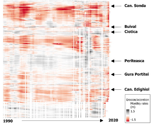
 A retrospective of more than 25 years has been compiled, describing historical and recent changes affecting European coastlines using satellite data, including that from the European Copernicus programme (Sentinel-1 and Sentinel-2). This unique satellite resource provides products which describe beach and coastline dynamics in terms of coastline position, evolution of sedimentary structures and associated sand stocks, as well as characterisation of coastal erosion exposure.
To confirm the “great power” of these results, the structures in charge of studying and managing coastal erosion – State services, managers of protected natural areas – were able to use, evaluate, and compare the coastal erosion indicators produced on their territory with the highly accurate but small-scale field measurements. All this was done under the supervision of regional scientific actors involved in the national network of coastline observatories. The final work was highlighted and shared more widely with the specialised scientific community during a special session of the major European Conference Living Planet Symposium, organised on 24 May 2022 in Bonn (Germany) by ESA.
With a few weeks to go before the end of the programme, it is clear that these new tools are an alternative and/or a support to traditional methods of monitoring the evolution of beaches and coastlines (field monitoring, aerial flights), in a context of climate change and rapid evolution, by providing:
- A relevant multi-scale vision of the processes affecting coastal areas;
- A significant added value for coastal managers, by providing them with permanently updated data, in a very short time and at a lower cost, on the entire territory, synthesised into up-to-date information on the exposure of their coastline to erosion.
This year, ESA is supporting a new phase of the project: accelerating the awareness of coastal communities and decision-makers on the interest of these tools and their appropriation. To do so, after a series of public seminars conducted in 2020 and 2022 in the pilot regions (which gathered nearly 200 participants), the project team will organise training sessions in the 6 European countries in the spring of 2023. Beyond these events, a professional tutorial on how to obtain and use the final products available at the end of the project will soon be made public.
Furthermore, the perspective of a future integration of these tools into Copernicus services could allow their operational deployment on a European scale.
The ESA Coastal Erosion Programme partners

TERRASIGNA and SCMF team of researchers:
Georgiana Anghelin – georgiana.anghelin@terrasigna.com
Sorin Constantin – sorin.constantin@terrasigna.com
Ioan-Daniel Șerban – ionut.serban@terrasigna.com
Florin Tătui – florin.tatui@geo.unibuc.ro